
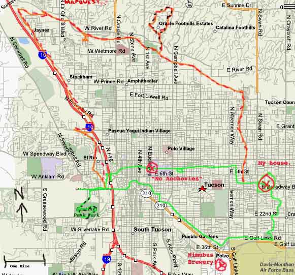

After the meeting yesterday it was noon and I knew I was a free man for the rest of the week. Naturally I headed to No Anchovies for a couple of slices and a glass of Nimbus.
I decided even tho I didn't have my bike shorts I'd take a long ride home. I settled on the Aviation corrider via 4th Avenue. Not bad at all. You get to cross the snake-bridge and go thru that odd neighborhood south of the Country House (now called Chafin's- it's the place that used be a Sambo's, and where you still get huge amounts of potatoes with your eggs and kind of bad, wood-tasting coffee). Hit the corridor and it's kind of uphill along the route across from the tracks. It looks like you're riding in a storm drain in some places, and there's graffiti, and it smells like sewers. You pass thru neighborhoods of people who have a lot of cars in their yards, home-made hand-welded barBQ's, and industrial places like car repair shops, fleet maintenance businesses and etc.
If you follow the trail to the end you get dumped out by the west edge of the base, about a quarter mile from Nimbus brewery. It's inhospitable w/o a mountain bike around that part, but not inacessible. I kind of had a tough time getting to the bike trail that follows along Golf Links, but it *looks* like if you catch 36th st. near the end of the corridor, 36th will dump you off right across from the bike trail, and there's a traffic light to get you across the howling, anonymous concrete stretch of highway.
In fact, that whole area looks like something out of a J.G. Ballard book, highways going everywhere, concrete walls, and patches of land in between with nothing but mesquites- no trash, no homeless, no rocks, just totally forgotten invisible patches of dirt, mostly triangular in shape. Ballard's book I'm thinking of is Concrete Island- people get stuck in one of those places and have to live there indefinitely.
So, you get to follow the bike trail east along Golf Links along a huge rock filled wash, thick w/ mesquites. There are fake rocks along the trail here and there, w/ graffiti, one of them smashed so you can see its hollow inside. Swan is a mile. You cross, head north thru a huge deserted park and past more backyards of an inexpensive neighborhood, across 29th, across 22nd, and as you approach Broadway you see the big dumb skyscraper you can see from my backyard. From there it's a half mile to my house. About 15 miles, I believe- I can't find my detailed city-map to check it out tho.
Anyway, a pretty good street ride, but it's over too quick- a half hour after you get warmed up, in fact.
Adding to the ride would be along the lines of, say, starting from my house, heading north to the Rillito river trail, catching it at Craycroft, then going west. There is a mile of dirt between Country Club and Campbell- nothing street bikes couldn't handle. Near Campbell, there are dozens of variations on a foothills street hill-climb-loop that can be added. I think then down Mountain, hit No Anchovies for beer and food, west to 4th ave, go south and hit the Aviation Corridor, and home via the route I just described above. If it's a festive occasion, hit Nimbus on the way home for more beer!!
Other options are adding a loop up A Mountain. Or heading to the end of the Rillito in the west, then south to the downtown/ UA area. The (street) connection between the west end of the Rillito and paved part of the Santa Cruz river trail is fuzzy, but it's there. Someday they'll pave the stretch of the trail north of Grant; they're definitely planning that.
Anyway the point is that this street ride is something approaching your San Fran city loop, in terms of distance, difficulty, and the idea of circling the whole city.
No comments:
Post a Comment